All Case Study

Plotline: Streamlining Site Assessment, Documentation & Project Planning
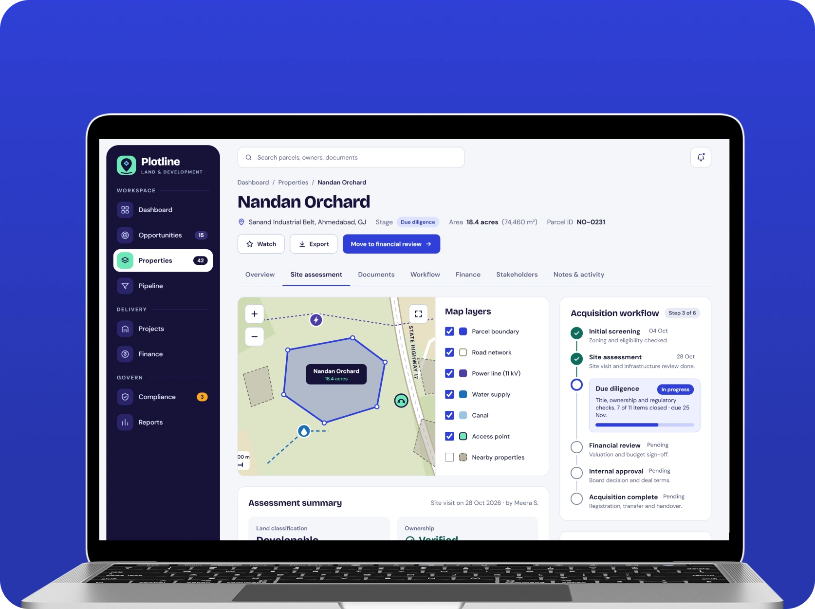
A comprehensive land acquisition and development management platform designed to simplify property evaluation, centralize land records, and streamline real estate project operations. The solution brings site assessment, acquisition workflows, document management, financial planning, regulatory tracking, and project monitoring into a unified digital environment. By connecting critical land development activities, the platform helps organizations improve operational visibility, organize property information, and manage development projects more efficiently.
Introduction
Land acquisition and real estate development involve multiple interconnected activities, including property evaluation, ownership verification, financial assessment, regulatory documentation, and development planning. Managing these activities across disconnected spreadsheets, emails, and document repositories can create information gaps, approval delays, and difficulties tracking project progress.
The objective was to conceptualize Plotline, a centralized land acquisition and development management platform that simplifies the complete property development lifecycle. The solution was designed to help organizations evaluate land opportunities, organize property documentation, manage acquisition pipelines, monitor development costs, and coordinate project approvals through a unified system. The platform also required a flexible architecture capable of supporting multiple properties, development projects, user roles, and location-based information.
Tech Stack
 React.js
 TypeScript
 Node.js
 PostgreSQL
 Mapbox
 AWS
Key Features

Land Opportunity & Property Portfolio Management
Designed a centralized property management module that allows organizations to maintain structured records of potential acquisition opportunities and existing land assets. Each property profile can include location details, land classification, ownership information, acquisition stage, estimated value, and associated documentation. The system provides a consolidated property portfolio view, helping decision-makers organize opportunities and monitor acquisition activities across different locations.
Geospatial Site Assessment & Location Intelligence
Integrated location-based visualization capabilities to support geographical property evaluation and site assessment. Interactive maps provide a visual representation of land locations, property boundaries, surrounding infrastructure, and relevant geographical information. Spatial data can be organized using geospatial database capabilities, helping development teams evaluate site characteristics and understand location-specific considerations before progressing with acquisition decisions.
Digital Land Records & Document Management
Developed a centralized document management framework to organize important property-related records, including ownership documents, title information, survey reports, legal agreements, permits, and supporting files. Authorized users can upload, categorize, retrieve, and review documentation through structured property records. Document version management and controlled access provide a foundation for better information organization and more transparent acquisition workflows.
Acquisition Pipeline & Approval Workflow Management
Introduced a structured acquisition management workflow that helps organizations track properties through different evaluation and approval stages. The system can organize activities such as initial screening, due diligence, financial review, legal verification, internal approvals, and acquisition completion. Configurable workflow stages and approval assignments provide better visibility into pending activities, responsible team members, and outstanding requirements.
Development Budgeting & Financial Tracking
Designed a financial management module to organize land acquisition expenses, development budgets, estimated project costs, and financial commitments. The platform can maintain property-level and project-level financial records, allowing administrators to review planned versus actual expenses. Centralized financial visibility helps organizations assess project requirements, identify budget variations, and support more informed investment planning.
Project Milestone Management & Performance Analytics
Created a centralized project monitoring environment to manage development timelines, assigned responsibilities, approval milestones, and project progress. Interactive dashboards provide visibility into ongoing activities, upcoming deadlines, project stages, and operational performance. Reporting capabilities help management review portfolio-level information, identify potential delays, and coordinate development activities across multiple properties.
Challenges
-
Fragmented Property Information & Land Records
Land acquisition activities often involve multiple documents, property records, financial details, and location-based information stored across disconnected systems. Establishing a centralized information management environment required structured property records and organized documentation workflows.
-
Complex Property Evaluation & Site Assessment
Evaluating land opportunities requires reviewing geographical characteristics, surrounding infrastructure, property boundaries, and location-specific considerations. Bringing relevant spatial information into a unified interface required geospatial integration and structured property data management.
-
Manual Acquisition & Approval Processes
Property acquisition involves several evaluation stages, internal approvals, and coordination between different departments. Managing these activities manually can make it difficult to track pending requirements, assigned responsibilities, and acquisition progress.
-
Limited Financial & Development Cost Visibility
Managing acquisition expenses, development budgets, and project-related financial commitments across multiple properties can create reporting challenges. The platform needed centralized financial records and reporting capabilities to improve budget visibility and support investment decisions.
-
Project Coordination & Operational Reporting
Real estate development projects involve multiple milestones, stakeholders, documentation requirements, and timelines. Maintaining consistent project visibility across different properties required a structured monitoring environment with centralized reporting and progress tracking.
Our Approach
-
Requirement Analysis & Platform Architecture
Established a modular platform architecture based on land acquisition, property evaluation, document management, financial planning, and development monitoring requirements. Defined the major user roles, business workflows, and data relationships to create a scalable foundation capable of supporting multiple properties and development projects.
-
Geospatial Integration & Property Data Management
Focused on integrating location-based functionality using Mapbox and PostgreSQL with PostGIS capabilities. Designed structured property data models to organize geographical information, site details, and associated records. This approach provides a centralized foundation for location-based property evaluation and portfolio management.
-
Frontend & Backend Application Development
Planned the frontend experience using React.js, TypeScript, and Material UI to provide intuitive dashboards and structured property management interfaces. Backend services using Node.js and Express.js support application workflows, property records, approval processes, and communication between platform modules through REST APIs.
-
Document Management & Business Workflow Automation
Designed centralized document storage using AWS S3 and structured workflows for acquisition stages, document reviews, approvals, and project activities. Authentication and access management using JWT and OAuth 2.0 provide a foundation for controlled information access across different user roles.
-
Cloud Deployment, Testing & Performance Optimization
Selected AWS infrastructure, Docker, and Nginx as the proposed deployment foundation. Focused on functional validation, API testing, geospatial data verification, document management testing, and workflow validation to establish a reliable platform architecture that can accommodate future operational requirements.
Results & Impact
Plotline establishes a centralized environment for managing property opportunities, site assessments, acquisition documentation, financial planning, and development activities. By connecting these processes through a unified digital ecosystem, the solution creates a foundation for more organized property management and improved visibility across the development lifecycle.
The integrated architecture supports structured property records, location-based evaluation, digital documentation, acquisition workflows, and project monitoring. Centralized dashboards and reporting capabilities also help management access relevant operational information without depending on disconnected records and manual reporting processes.
Key expected business benefits include:
-
Centralized Property Management
Organizes land opportunities, property information, and acquisition records within one platform.
-
Improved Site Evaluation
Provides location-based visualization and structured geographical information to support property assessment.
-
Streamlined Documentation
Simplifies the organization, retrieval, and management of property-related documents.
-
Better Acquisition Visibility
Provides structured approval workflows and acquisition-stage tracking to improve process coordination.
-
Enhanced Financial Oversight
Centralizes acquisition expenses, development budgets, and project-related financial information.
-
Efficient Project Monitoring
Supports milestone tracking, development progress visibility, and portfolio-level reporting.
-
Scalable Business Operations
Establishes a flexible architecture to accommodate additional properties, projects, users, and future integrations.

Let’s Build Something
Exceptional
Innovify transforms ideas into impactful products, blending design and engineering from concept to scale. Through onshore and nearshore collaboration, we deliver speed, clarity, and top talent without compromise.
Visit Portfolio
See More Case Studies
Our clients speak for us! Our Clutch-verified reviews reflect our dedication to delivering top-notch solutions.