All Case Study

Traversa: Smart Infrastructure & Location Intelligence Management Platform
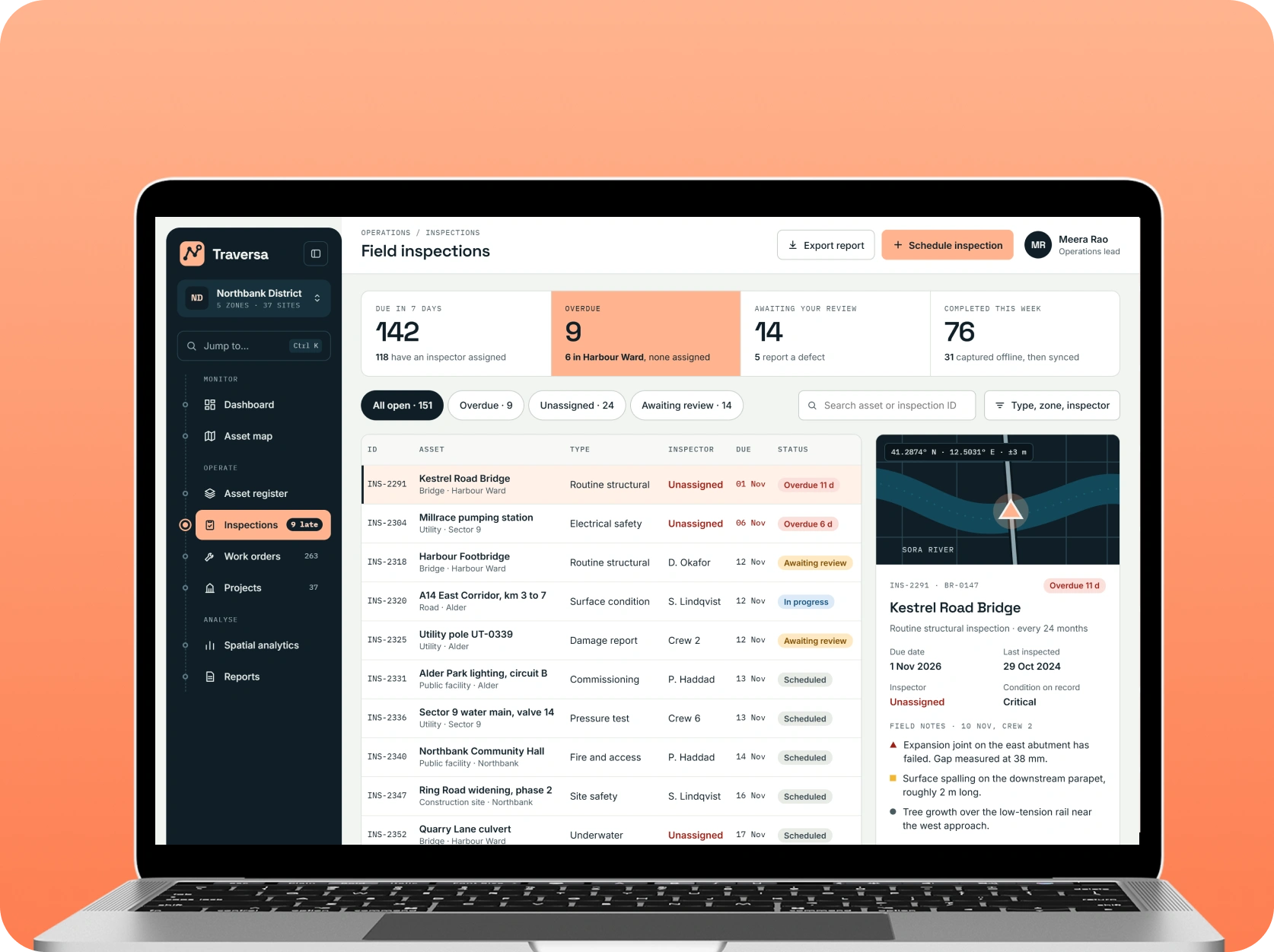
A comprehensive geospatial platform designed to simplify infrastructure asset management, streamline field operations, and improve location-based decision-making. The solution combines interactive mapping, centralized asset records, field inspection management, geographic data visualization, and spatial analytics to help organizations monitor infrastructure projects, coordinate field activities, and manage distributed physical assets through a unified digital environment.
Introduction
Organizations responsible for managing infrastructure across multiple locations often deal with fragmented asset records, disconnected field reporting systems, and limited visibility into ongoing operational activities. Managing roads, utilities, construction sites, public facilities, and other physical assets becomes increasingly challenging when location information and operational data are maintained across separate applications.
Traversa addresses these challenges through a centralized geospatial management ecosystem. It enables organizations to visualize infrastructure assets on interactive maps, maintain location-specific records, coordinate field inspections, manage operational tasks, and analyze geographic information through centralized dashboards.
The platform connects location intelligence with everyday infrastructure management workflows, allowing administrators and field teams to access relevant asset information, document site activities, monitor project progress, and maintain structured operational records. Its modular architecture supports multiple infrastructure categories and provides a foundation for expanding geographic data management capabilities as organizational requirements evolve.
Tech Stack
 Next.js
 React Native
 NestJS
 PostgreSQL
 AWS
Key Features

Interactive Geospatial Asset Mapping
Provides an interactive geographic interface for visualizing infrastructure assets, operational locations, project boundaries, and site-specific information. Users can explore mapped locations, apply geographic filters, view asset details, and navigate between different infrastructure categories. The mapping interface connects physical locations with associated operational records, helping organizations maintain a unified geographic view of their infrastructure.
Centralized Infrastructure Asset Management
Offers a structured system for registering, organizing, and managing infrastructure assets across multiple locations. Administrators can maintain asset identifiers, classifications, installation information, ownership details, operational status, and supporting documentation. Centralized asset records help reduce information fragmentation and make infrastructure-related information easier to access and maintain.
Field Inspection & Mobile Data Collection
Enables field personnel to conduct site inspections and record infrastructure-related information through mobile-friendly interfaces. Teams can capture GPS coordinates, upload photographs, document observations, and update inspection records directly from their devices. Offline data capture capabilities can support field activities in areas with limited network connectivity, with synchronization when connectivity becomes available.
Location-Based Work Order Management
Connects infrastructure assets and geographic locations with operational tasks and maintenance activities. Administrators can create work orders, assign responsibilities, establish deadlines, and monitor task progress through centralized dashboards. Location-based task organization helps field teams understand where activities need to be performed and allows managers to maintain better visibility into ongoing operations.
Geographic Data Visualization & Spatial Analytics
Transforms geographic datasets into meaningful visual information through interactive maps, location-based filters, and spatial reporting. Users can analyze asset distribution, identify geographic clusters, review infrastructure coverage, and compare location-specific operational information. Spatial analytics supports infrastructure planning and helps organizations understand geographic patterns across their managed environments.
Project Monitoring & Operational Reporting
Provides centralized reporting capabilities for monitoring infrastructure projects, inspection activities, asset conditions, and field operations. Administrators can review project progress, track outstanding tasks, evaluate inspection records, and generate operational reports. These capabilities help management teams maintain better oversight of distributed projects and support informed resource allocation.
Challenges
-
Fragmented Geographic & Infrastructure Information
Infrastructure-related records were difficult to manage when asset information, geographic coordinates, inspection documents, and project updates were distributed across separate systems. A unified platform was needed to connect location information with operational records.
-
Limited Visibility Across Distributed Assets
Managing infrastructure across multiple geographic areas creates challenges in tracking asset conditions, project activities, and field operations. Without interactive mapping and centralized reporting, administrators may struggle to obtain a consistent overview of geographically distributed assets.
-
Inefficient Field Reporting & Data Collection
Traditional field reporting processes often depend on manual documentation, disconnected tools, and repetitive data entry. Field teams require an accessible way to capture geographic information, document site observations, and update operational records efficiently.
-
Complex Geographic Data Processing
Infrastructure management involves handling different geographic datasets, spatial boundaries, location coordinates, and supporting documents. Processing and visualizing this information requires a reliable geospatial architecture capable of supporting efficient data storage, retrieval, and map-based presentation.
Our Approach
-
Geospatial Architecture & Infrastructure Assessment
Evaluated infrastructure management requirements, geographic data sources, asset classification structures, user responsibilities, and operational workflows. Designed a centralized platform architecture that connects geographic information with infrastructure asset records, inspection activities, and project management processes.
-
Interactive Mapping & Spatial Data Integration
Established an integrated geospatial architecture using mapping libraries and spatial database capabilities. Structured the platform to manage geographic coordinates, asset boundaries, location information, and infrastructure-related datasets while providing interactive map-based visualization and geographic filtering.
-
Field Operations & Workflow Development
Designed mobile-friendly workflows for field inspections, GPS-based data collection, asset updates, and location-based work orders. The approach considered offline data capture, structured inspection records, task assignments, and synchronization to improve coordination between field personnel and administrative teams.
-
Cloud Infrastructure & Platform Optimization
Structured cloud infrastructure to support geospatial data storage, application services, API communication, and geographic data processing. Implemented a scalable deployment approach with authentication, access permissions, data validation, and application monitoring to support platform reliability and future expansion.
Results & Impact
Traversa establishes a centralized digital environment for connecting geographic information with infrastructure asset management and field operations.
By integrating interactive mapping, centralized asset records, mobile data collection, location-based work orders, and spatial analytics, the solution provides organizations with a more structured approach to managing geographically distributed infrastructure. Administrative teams gain improved visibility into asset information and project activities, while field personnel can capture location-specific updates through organized digital workflows.
The platform’s modular architecture also provides a foundation for managing additional infrastructure categories, incorporating new geographic datasets, and expanding location-based operational capabilities. Its centralized data model supports more consistent information management and creates opportunities for organizations to improve infrastructure planning through geographic intelligence.
Business Benefits:
- Centralized management of geographically distributed infrastructure assets
- Interactive visualization of infrastructure locations and project boundaries
- Improved accessibility of location-specific asset information
- Structured field inspections and GPS-based data collection
- Better coordination of location-based work orders and operational tasks
- Improved visibility into infrastructure projects and field activities
- More organized geographic information and spatial reporting
- Scalable architecture for expanding geospatial management capabilities

Let’s Build Something
Exceptional
Innovify transforms ideas into impactful products, blending design and engineering from concept to scale. Through onshore and nearshore collaboration, we deliver speed, clarity, and top talent without compromise.
Visit Portfolio
See More Case Studies
Our clients speak for us! Our Clutch-verified reviews reflect our dedication to delivering top-notch solutions.